Maine’s scenic byways offer more than beautiful views of forests, mountains, the ocean, and waterways. They are also gateways to Maine outdoor recreation opportunities for every season. Explore one of our sixteen scenic byways and discover your next adventure!
Quick Jump – Select a Region Below:
- The County (Fort Kent, Caribou, Presque Isle, Houlton)
- Highlands (Bangor, Moosehead, Millinocket, Lincoln, Dover-Foxcroft)
- Downeast & Acadia (Eastport, Machias, Ellsworth, Bucksport, Bar Harbor)
- Midcoast (Belfast, Camden, Rockland, Damariscotta, Bath, Brunswick)
- Kennebec Valley (Jackman, Bingham, Skowhegan, Waterville, Augusta, Gardiner)
- Western Mountains & Lakes (Rangeley, Farmington, Bethel, Winthrop, Lewiston, Auburn)
- South & Casco Bay (Portland, Freeport, Yarmouth, Old Orchard Beach, Kennebunk, Kittery)
The County
Fish River Scenic Byway (Route 11)
Distance: 37 miles
Time: 1 hr
Recreation: Beaches, swimming, boating, canoeing, kayaking, fishing, golf, hiking, landmarks, water views, mountain views, snowmobiling, parks, wildlife
Destinations: Fort Kent Blockhouse, Fort Kent Historical Society, Allagash Wilderness Waterway, Aroostook State Park
Printable Maps & Brochures:
Basic map of Route 11 – a simple map of route and Maine map.
Million Dollar View Scenic Byway (Route 1)
Distance: 8 miles (from The County to Downeast & Acadia)
Time: 1 hr
Recreation: Boating, canoe, kayak, fishing, ATV, hiking, water views, mountain views, skiing, snowmobiling, wildlife
Destinations: Grand Lake, East Grand Highlands Hiking Trail, Woodie Wheaton Land Trust
Printable Maps & Brochures:
Basic map of Route 1 – a simple map of route and Maine map.
Saint John Valley Scenic Byway
Distance: 82+ miles
Time: 2+ hrs
Recreation: bicycling, boating, camping, canoe, kayak, fishing, ATV, hiking, landmarks, water views, snowmobiling, park, wildlife
Destinations: Fort Kent Block House, Acadian Village Living History Site
Printable Maps & Brochures:
Basic map of St. John Valley Byway – a simple map of route and Maine map.
Highlands
Katahdin Woods & Waters Scenic Byway
Distance: 89 miles (paved and dirt roads)
Time: depends on destination/route
Recreation: Boating, camping, canoe, kayak, fishing, hiking, landmarks, water views, mountain views, whitewater, snowmobiling, park, wildlife
Destinations: Baxter State Park, Mount Katahdin, Shin Falls, Grindstone Falls, Debsconeag Ice Caves, Ash Hill, Boom House, Golden Road, West Branch Penobscot River, Katahdin Woods & Waters National Monument.
Printable Maps & Brochures:
Map of Katahdin Woods & Waters Scenic Byway Route – detailed map of the route including outdoor activities and trails.
Moosehead Lake Scenic Byway
Distance: 59 miles (Kennebec Valley & Highlands Regions)
Time: depends on destination/route
Recreation: Boating, camping, canoe, kayak, fishing, hiking, water views, mountain views, skiing, snowmobiling
Destinations: Mt. Kineo, Kennebec River Gorge, Moxie Falls, Little Wilson Gorge, Big Wilson Cliffs, Borestone Mountain, Lily Bay State Park, Low’s Covered Bridge, Moose River Loop/Bow Trip
Printable Maps & Brochures:
Map of Moosehead Lake Scenic Byway – detailed map the of the route.
Downeast & Acadia
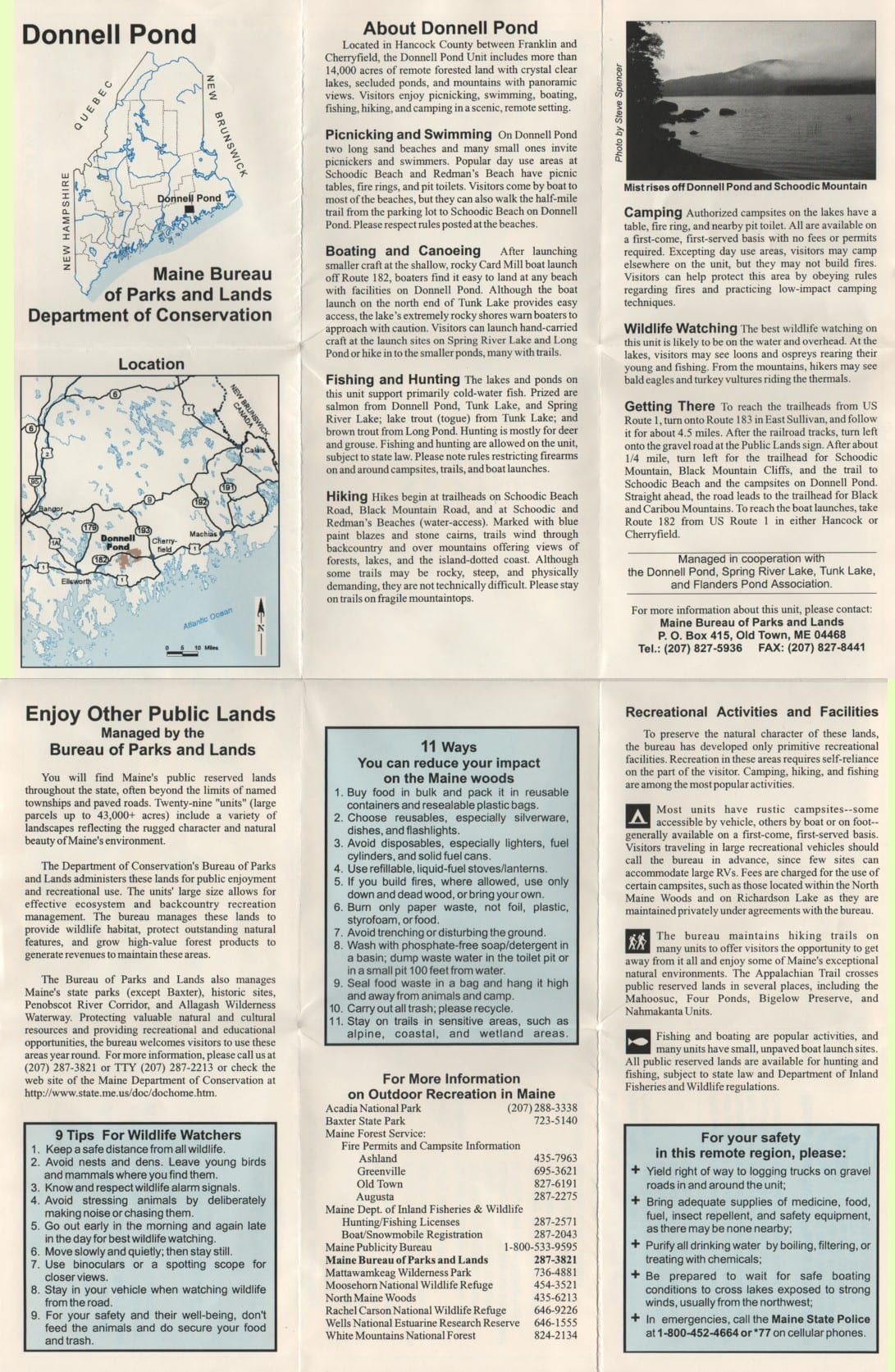
Blackwoods Scenic Byway (Route 182)
Distance: 12.5 miles
Time: .5hrs
Recreation: biking, boating, canoeing, fishing, kayaking, hiking, water views, mountain views, ocean views, wildlife
Destinations: Donnell Pond Public Reserve Land, Schoodic Mountain, Hog Bay (bird watching)
Printable Maps & Brochures:
Basic map of Route 182 – a simple map of route and Maine map.
Blackwoods Byway Adventures – map listing hiking locations, boat launches, campsites, picnic areas, swimming areas and overlooks.
Blackwoods Byway Brochure – map of hiking trails, multi-use trails, scenic overlooks, and descriptions of regional features.
Donnell Pond Preserve Map – map showing trails, campsites, picnic areas, wildlife viewing areas, and boat launches in the preserve.
Donnell Pond Brochure – provides a description of the area, rules, directions and additional information about the preserved lands.
Tunk Mountain & Hidden Ponds Hike – Arial map of the region outlining hiking trails.
Million Dollar View Scenic Byway (Route 1)
Distance: 8 miles (from The County to Downeast & Acadia)
Time: 1 hr
Recreation: Boating, canoe, kayak, fishing, ATV, hiking, water views, mountain views, skiing, snowmobiling, wildlife
Destinations: Grand Lake, East Grand Highlands Hiking Trail, Woodie Wheaton Land Trust
Printable Maps & Brochures:
Basic map of Route 1 – a simple map of route and Maine map.
The Bold Coast Scenic Byway
Distance: 125 miles
Time: varies depending on destination
Recreation: bicycling, boating, camping, canoe, kayak, fishing, ATV, hiking, landmarks, ocean views, ski, snowmobile, wildlife
Destinations: Great Heath Public Reserve Land, Roque Bluffs State Park, Cutler Coast Public Reserve Land, Cobscook Bay State Park, Moosehorn National Wildlife Refuge, Shackford Head State Park, Roosevelt Campobello Park, Quoddy Head State Park, Main Island Trail, Downeast Sunrise Trail, Downeast Fisheries Trail, Lighthouses and Lobsters Trail, Ice Age Trail, Downeast and Acadia Birding Trail, Downeast Coastal Conservancy Trails
Printable Maps & Brochures:
Basic map of Bold Coast Scenic Byway – a simple map of route and Maine map.
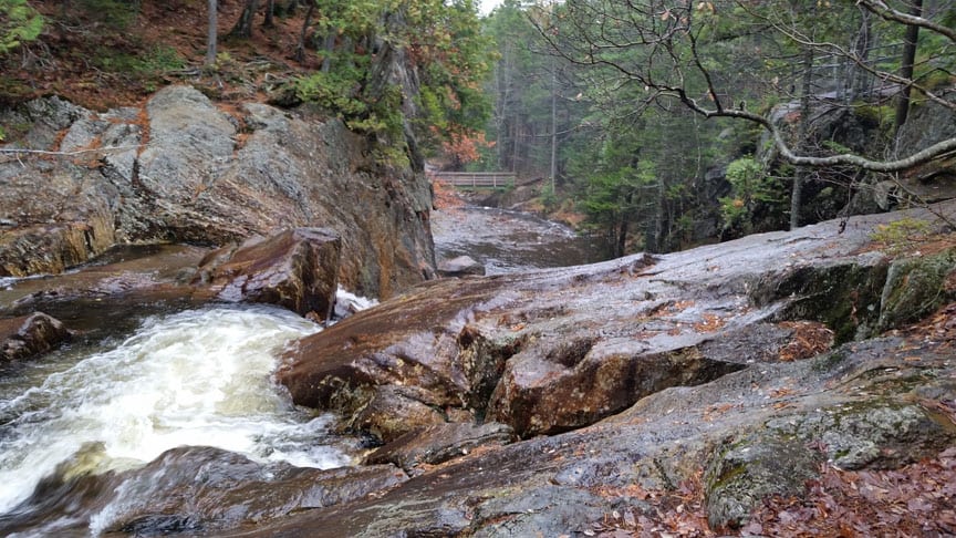
Schoodic National Scenic Byway
Distance: 29 miles
Time: 1.5 hrs
Recreation: bicycling, canoe, kayak, hiking, islands, lighthouses, mountain views, ocean views, park, wildlife
Destinations: Acadia National Park, Tunk Mountain, Ice Age Trail, Schoodic Point, Taunton Bay, Tidal Falls, Preble Cove, Frenchman Bay
Printable Maps & Brochures:
Basic map of Schoodic National Scenic Byway – a simple map of route and Maine map.
Schoodic Outdoors Brochure – Highlighting things to do in the Schoodic region.
Schoodic Outdoors Map – Companion to the brochure, showing locations of things to do in the Schoodic region.
Schoodic Scenic Byway Brochure page 1 – Things to do.
Schoodic Scenic Byway Brochure page 2 – Places to visit.
Schoodic Scenic Byway Brochure page 3 – Companion map showing locations of things to do and places to visit.
Acadia All-American Road
Distance: 40 miles
Time: 3 hrs
Recreation: Beaches, swimming, bicycling, hiking, islands, water views, lighthouses, mountain views, ocean views, skiing, park, wildlife
Destinations: Acadia National Park, Cadillac Mountain, Echo Lake, Isle au Haut, Jordan Pond House, Sand Beach, Thunder Hole
Printable Maps & Brochures:
Basic map of Acadia All-American Road – a simple map of route and Maine map.
Midcoast
No scenic byways in this region.
Kennebec Valley
Moosehead Lake Scenic Byway
Distance: 59 miles (Kennebec Valley & Highlands Regions)
Time: depends on destination/route
Recreation: boating, camping, canoe, kayak, fishing, hiking, water views, mountain views, skiing, snowmobiling, wildlife
Destinations: Mt. Kineo, Kennebec River Gorge, Moxie Falls, Little Wilson Gorge, Big Wilson Cliffs, Borestone Mountain, Lily Bay State Park, Lowes Covered Bridge, Moose River Loop/Bow Trip
Printable Maps & Brochures:
Map of Moosehead Lake Scenic Byway – detailed map of the route.
Old Canada Road National Scenic Byway (Route 201)
Distance: 78 miles
Time: depends on destination/route
Recreation: beaches, swimming, bicycling, boating, camping, canoe, kayak, fishing, hiking, water views, mountain views, whitewater, skiing, snowmobiling, wildlife
Destinations: Solon-Bingham Rail Trail, Appalachian Trail, Moose River Loop/Bow Trip
Printable Maps & Brochures:
Map of Old Canada Road Scenic Byway – a simple map of route and Maine map.
Western Mountains & Lakes
Grafton Notch Scenic Byway (Route 26)
Distance: 21 miles
Time: 3 hrs
Recreation: bicycling, golf, hiking, water views, mountain views, skiing, park, wildlife
Destinations: Spruce Meadow, Appalachian Trail, Grafton Loop Trail, Covered Bridge
Printable Maps & Brochures:
Basic map of Grafton Notch Scenic Byway – a simple map of route and Maine map.
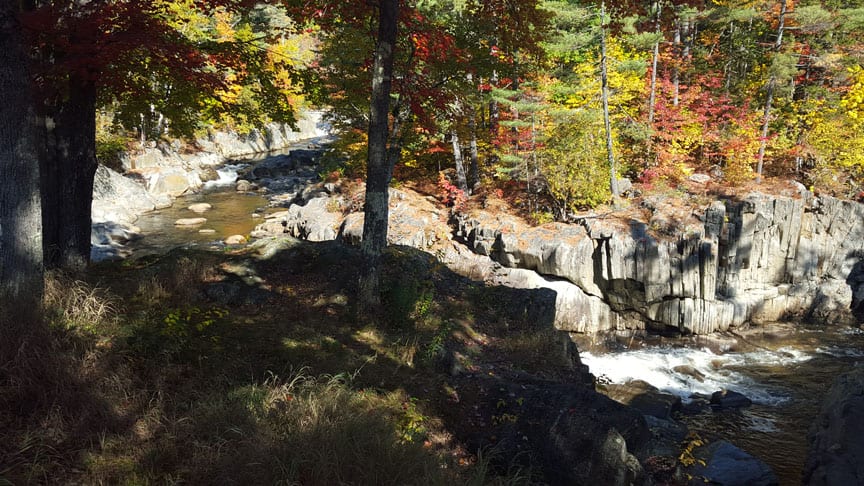
Pequawket Trail Scenic Byway (Route 113)
Distance: 60 miles
Time: 2 hrs
Recreation: beaches, swimming, bicycling, boating, camping, canoe, kayak, fishing, hike, landmarks, water views, mountain views, ski, snowmobile, park, wildlife
Destinations: Hemlock Covered Bridge, Mount Cutler, Burnt Meadow Mountain Trail, Mountain Division rail trail, Sebago Lake State Park, White Mountain National Forest.
Printable Maps & Brochures:
Basic map of Pequawket Trail Scenic Byway – a simple map of route and Maine map.
State Route 27 Scenic Byway
Distance: 47 miles
Time: 1.5 hrs
Recreation: bicycling, boating, camping, canoe, kayak, fishing, golf, hiking, water views, mountain views, whitewater, ski, snowmobile, wildlife
Destinations: “Moose Alley” (Route 16 from Stratton to Rangeley), Narrow Gauge Railroad Trail, Appalachian Trail.
Printable Maps & Brochures:
Basic map of State Route 27 Scenic Byway – a simple map of route and Maine map.
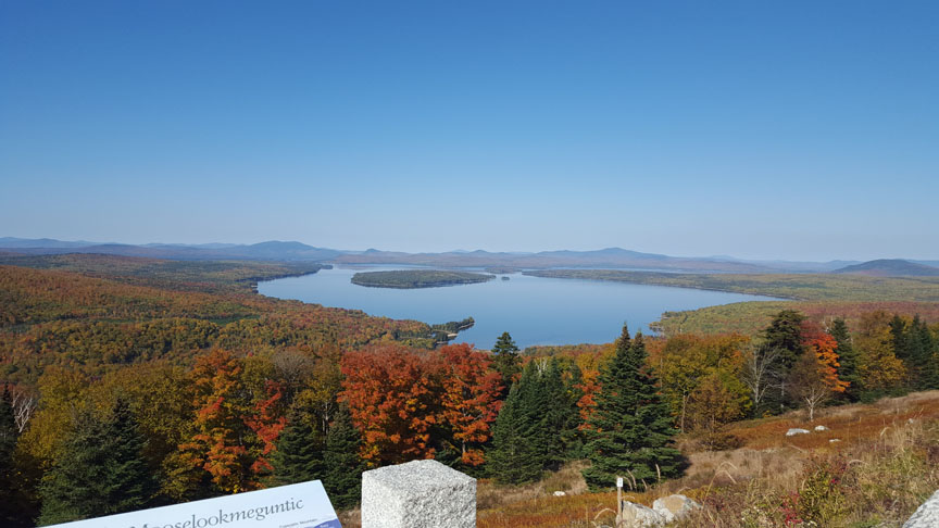
Rangeley Lakes National Scenic Byway
Distance: 52 miles
Time: 2.5 hrs
Recreation: bicycling, boating, camping, canoe, kayak, fishing, golf, hiking, water views, mountain views, ski, snowmobile, wildlife
Destinations: Angel Falls, Appalachian Trail, Coos Canyon, Rangeley Lake State Park, Height of Land, Smalls Falls, Tumbledown Mountain, Mount Blue State Park, Bald Mountain
Printable Maps & Brochures:
Basic map of Rangeley Lakes National Scenic Byway – a simple map of route and Maine map.
South & Casco Bay
No scenic byways in this region.